by lakwatserong tatay
After a quickie hike to Mt. Talamitam, and sidetrip to Layong Bato River, our group proceeded to our next destination. The province of Taal, locals said this is a counterpart of Vigan's historical street, "Calle Crisologo". However our main goal, why we visit this town is to see the "Asia's Biggest Catholic Church", known as "Taal Basilica".
Taal Basilica is certainly the biggest church in Asia because of its colossal baroque structures made of adobe and coral stones. This church has 96mtrs long, 45 mtrs wide and 96 mtrs tall. Its facade has 24 classical columns in pairs and lined up two rows of six on top on the others, with 10 windows and 5 doors. Its edifice topped with a triangular roof and gable on each side and one in the center. Its bell tower rises on the left side.

History of Taal Basilica
Original town of Taal was founded by Augustinian missionaries in 1572 on the banks of the Taal Lake (Municipal of San Nicolas can be found). Fr. Diego Espinar led the construction of the town’s very first church in 1575. In almost two centuries, the church continued to improve and was rebuilt only to be utterly destroyed in 1754 after the biggest explosion of nearby Taal Volcano. It wasn’t just the church, though, as the whole town of old Taal was so devastated. The town moved to its current location, on top of a hill overlooking Balayan Bay. In 1755, the construction of a new church was launched under Fr. Martin Aguirre.
Over several decades, new elements and features were added for the beautification of the church. However, on September 16, 1852, tragedy struck yet again. A massive earthquake hit the province and destroyed the church. Four years after the catastrophe, another church was built at the same site under Fr. Marcos Anton, who commissioned architect Luciano Oliver to create the design and run the construction. In 1865, almost a decade later, the newly erected church was inaugurated despite its unfinished state. The construction was finally completed in 1878 with the addition of its gigantic 79 ft altar under the supervision of Fr. Agapito Aparicio. It was a massive church, the biggest at the time and would remain the biggest even centuries later. On January 16, 1974, it was declared as one of the country’s National Shrines.
Who will not be amazed if you will see this kind of interiors. With its gigantic paintings makes you feel you've visited a church maybe in Europe. It really make picturesque perfect with it each angle. With its high ceilings and so clear paintings, up to its gigantic altar, who among the couples wouldn't want to have wedding on this church. Personally, i would love to have it here....^_^


This church has a lighter atmosphere than the other churches i've been with. Maybe because of its paintings, walls, ceilings. The paints looked like a three-dimensional patterns from afar. The main altar has 24 mtrs high and 10 mtrs wide with three doric columns lined up on each side of the centerpiece where the statue of crucified Jesus stands. There are other statues of angels and saints within the main altar. The church has minor altars with more images of saints. The altars lights is showered coming from the windowed dome above.


Aside from this prominent structure in Taal. Lies within Taal Basilica is Taal Park, Taal Heritage Center, Rizal College and Our Lady of Caysasay Academy, The Municipal Hall of Taal also stands nearby. Taal's Public Market, where vendors of Batangas delicacies and other street food abound in the park.


The Town of Taal is can be explored by foot. Once you're at the Taal Park, you have an option to see and visit the ancestral houses of Taal, The Well of Sta. Lucia, The Public Market, where you could eat the famous empanda, and the Shrine of Our Lady of Caysasay are just a few minutes walk away.
Here are some of my photos while walking around Taal's Ancestral Houses going to Taal's Public Market.


We had also the chance to try one of the Taal's version of Empanada. This empanada is made of home made pies stuffed with chicken, pork, vegetables, mixed with potato and carrots. Taal's version also includes vermecelli and sotanghon, that makes it special. Empanada's are served warm, heartly and perfectly cooked in a way that keeps the empanada crust soft and the filling full of flavor. That makes this Taal's Empanada is one of the most famous merienda and best tasting empanada version i've had. A must try when you visit this town.


Here are some of the products and delicacies that this town offers, For their products, Balisong, which make this town as Balisong Capital of the Philippines. Burdang Taal, made of pineapple and abaca fibers, that uses an old hand native embroidery, Sawali, a craft weaving split bamboo into mats typically seen in nipa hut walls. Tsinelas, one of the local products and livelihood programs in Taal, is a thong type slip-ons. For their delicacies, Panutsa, one of the famous delicacy in Taal, made of locally grown peanuts cooked with sugar mixture. Sumang Taal, one of the famous pasalubongs in Taal, a home made, sweet, sticky, boiled rice cake wrapped in banana leaves. Tablea, filipino's hot chocolate. For their dishes, Tapang Taal, a must try when you're in Taal, best served with egss and fried rice. Longanisang Taal, one of Taal's delicacy people rave. Adobo sa Dilaw, one of the famous dished in our country, however Taaleño's cooked it with turmeric, giving it a delicious yellow curry twist. Tamales, one of the native delicacies in Taal, made of pork, eggs, and nuts mixed together in a sticky rice cake. Tawilis, one of the famous dishes in Taal, made of freshwater sardines, most of the eateries in the town offer this. Sinaing na Tulingan, a tuna mackarel from Taal lake, process in hours, broiled under a portion of pork fat giving it a savory flavor. Maliputo, another fish from Taal lake, some locals its a must try in the town, however because its quite pricey, it rarely can be seen in eateries in Taal. And lastly, and one of my favorite, Batangas Lomi, a chinese-filipino noodle broth, sauteed with small pieces of pork or chicken meat, liver, and vegetables. Thickened with cassava flavor and beaten egg and topped with kikiam.
How to get there:
By Private Vehicle:
There are two ways to reach Taal from Manila. The first route, the easier one, uses the STAR Tollway or the Southern Tagalog Arterial Road.
Drive through SLEX. Drive straight to STAR Tollway and exit at Tambo (Lipa City). Turn right from the exit and follow the signs to Cuenca. Stay on the national highway and you’ll pass through the towns of Alitagtag and Sta. Teresita.When you reach the Sta. Teresita junction, turn right and drive straight until you reach the Taal-Lemery Bypass Junction (watch out for a Flying V gas station). Turn left at the junction and follow the road and you’ll find the Taal Basilica easily.
Another way is to drive through Tagaytay City, which will give you a breathtaking view of the Taal Volcano.
Take the Sta Rosa Exit at SLEX and stay on the highway until you reach the Tagaytay Rotonda. Turn onto the Tagaytay-Nasugbu Road (marked by a 7-Eleven Store) and drive straight until you reach the Batangas-Cavite boundary. Turn left at the boundary. Caution: this is a difficult drive as the road zigzags sharply and there are deep ravines on both sides. If you see the Fantasy World as you drive farther, you know you’re on the right track. Drive straight until you reach a junction called Mahayahay Crossing — turn left and stay on that road. You’ll pass through Lemery Town Proper. When you cross the Pansipit Bridge, you have entered Taal territory.
By Public Utility Vehicle (Bus):
Take a bus bound for Lemery. Terminals of buses to Lemery can be found in the following:
Buendia, Pasay City near Gil Puyat LRT Station;
Kamias corner EDSA in Quezon City; and
Araneta Center in Quezon City.
Ask the driver whether it will pass through Taal Town Proper or not. If yes, alight at the town center, in front of the Basilica of St. Martin de Tours. If not, get off at the Taal-Lemery Bypass Junction and ride a jeepney to the town center of Taal. If you miss the junction, don’t worry. Alight at the Lemery Terminal (the last stop) instead and take a trike to the Taal Basilica.
After a quickie hike to Mt. Talamitam, and sidetrip to Layong Bato River, our group proceeded to our next destination. The province of Taal, locals said this is a counterpart of Vigan's historical street, "Calle Crisologo". However our main goal, why we visit this town is to see the "Asia's Biggest Catholic Church", known as "Taal Basilica".
 | |
| Taal Basilica |

 |
| Historical Marker |
History of Taal Basilica
Original town of Taal was founded by Augustinian missionaries in 1572 on the banks of the Taal Lake (Municipal of San Nicolas can be found). Fr. Diego Espinar led the construction of the town’s very first church in 1575. In almost two centuries, the church continued to improve and was rebuilt only to be utterly destroyed in 1754 after the biggest explosion of nearby Taal Volcano. It wasn’t just the church, though, as the whole town of old Taal was so devastated. The town moved to its current location, on top of a hill overlooking Balayan Bay. In 1755, the construction of a new church was launched under Fr. Martin Aguirre.
Over several decades, new elements and features were added for the beautification of the church. However, on September 16, 1852, tragedy struck yet again. A massive earthquake hit the province and destroyed the church. Four years after the catastrophe, another church was built at the same site under Fr. Marcos Anton, who commissioned architect Luciano Oliver to create the design and run the construction. In 1865, almost a decade later, the newly erected church was inaugurated despite its unfinished state. The construction was finally completed in 1878 with the addition of its gigantic 79 ft altar under the supervision of Fr. Agapito Aparicio. It was a massive church, the biggest at the time and would remain the biggest even centuries later. On January 16, 1974, it was declared as one of the country’s National Shrines.
 |
| the center door of the church |
 |
| one of the church's chandelier |


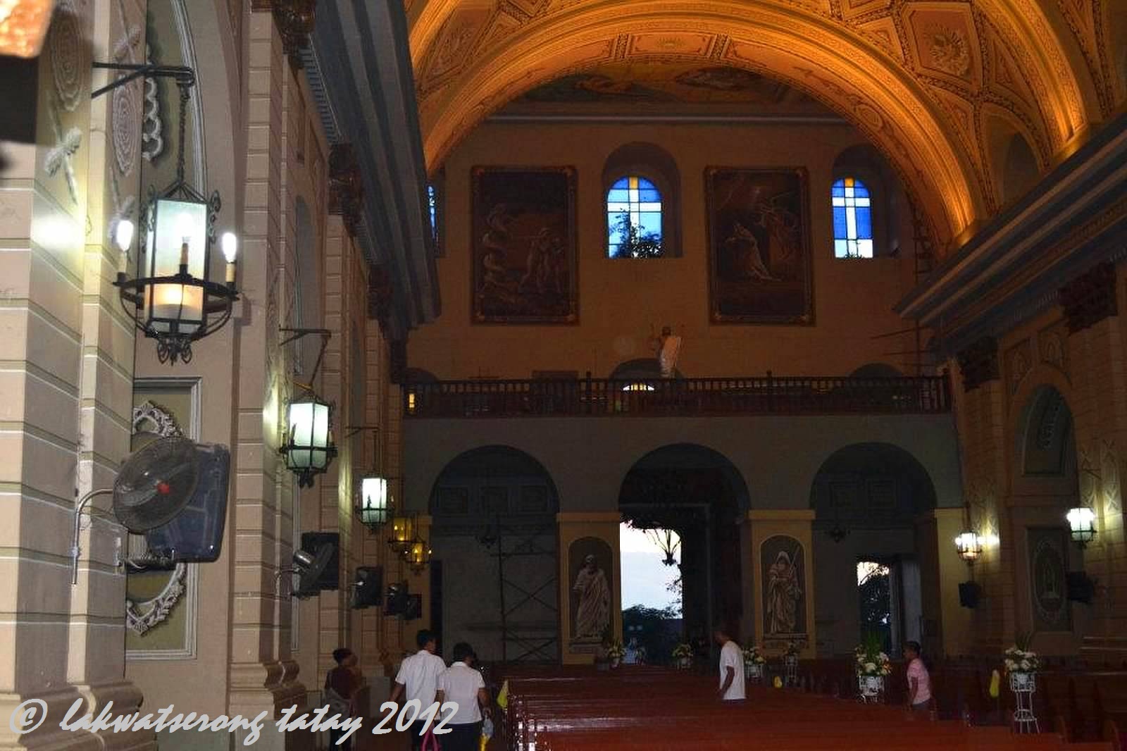
This church has a lighter atmosphere than the other churches i've been with. Maybe because of its paintings, walls, ceilings. The paints looked like a three-dimensional patterns from afar. The main altar has 24 mtrs high and 10 mtrs wide with three doric columns lined up on each side of the centerpiece where the statue of crucified Jesus stands. There are other statues of angels and saints within the main altar. The church has minor altars with more images of saints. The altars lights is showered coming from the windowed dome above.


 |
| two of the gigantic paintings at the 2nd floor |
 |
| One of Taal's Pride...."Taal Basilica" |


The Town of Taal is can be explored by foot. Once you're at the Taal Park, you have an option to see and visit the ancestral houses of Taal, The Well of Sta. Lucia, The Public Market, where you could eat the famous empanda, and the Shrine of Our Lady of Caysasay are just a few minutes walk away.
 |
| Taal Park |


We had also the chance to try one of the Taal's version of Empanada. This empanada is made of home made pies stuffed with chicken, pork, vegetables, mixed with potato and carrots. Taal's version also includes vermecelli and sotanghon, that makes it special. Empanada's are served warm, heartly and perfectly cooked in a way that keeps the empanada crust soft and the filling full of flavor. That makes this Taal's Empanada is one of the most famous merienda and best tasting empanada version i've had. A must try when you visit this town.


Here are some of the products and delicacies that this town offers, For their products, Balisong, which make this town as Balisong Capital of the Philippines. Burdang Taal, made of pineapple and abaca fibers, that uses an old hand native embroidery, Sawali, a craft weaving split bamboo into mats typically seen in nipa hut walls. Tsinelas, one of the local products and livelihood programs in Taal, is a thong type slip-ons. For their delicacies, Panutsa, one of the famous delicacy in Taal, made of locally grown peanuts cooked with sugar mixture. Sumang Taal, one of the famous pasalubongs in Taal, a home made, sweet, sticky, boiled rice cake wrapped in banana leaves. Tablea, filipino's hot chocolate. For their dishes, Tapang Taal, a must try when you're in Taal, best served with egss and fried rice. Longanisang Taal, one of Taal's delicacy people rave. Adobo sa Dilaw, one of the famous dished in our country, however Taaleño's cooked it with turmeric, giving it a delicious yellow curry twist. Tamales, one of the native delicacies in Taal, made of pork, eggs, and nuts mixed together in a sticky rice cake. Tawilis, one of the famous dishes in Taal, made of freshwater sardines, most of the eateries in the town offer this. Sinaing na Tulingan, a tuna mackarel from Taal lake, process in hours, broiled under a portion of pork fat giving it a savory flavor. Maliputo, another fish from Taal lake, some locals its a must try in the town, however because its quite pricey, it rarely can be seen in eateries in Taal. And lastly, and one of my favorite, Batangas Lomi, a chinese-filipino noodle broth, sauteed with small pieces of pork or chicken meat, liver, and vegetables. Thickened with cassava flavor and beaten egg and topped with kikiam.
 |
| Me @ Taal Basilica, Taal, Batangas |
By Private Vehicle:
There are two ways to reach Taal from Manila. The first route, the easier one, uses the STAR Tollway or the Southern Tagalog Arterial Road.
Drive through SLEX. Drive straight to STAR Tollway and exit at Tambo (Lipa City). Turn right from the exit and follow the signs to Cuenca. Stay on the national highway and you’ll pass through the towns of Alitagtag and Sta. Teresita.When you reach the Sta. Teresita junction, turn right and drive straight until you reach the Taal-Lemery Bypass Junction (watch out for a Flying V gas station). Turn left at the junction and follow the road and you’ll find the Taal Basilica easily.
Another way is to drive through Tagaytay City, which will give you a breathtaking view of the Taal Volcano.
Take the Sta Rosa Exit at SLEX and stay on the highway until you reach the Tagaytay Rotonda. Turn onto the Tagaytay-Nasugbu Road (marked by a 7-Eleven Store) and drive straight until you reach the Batangas-Cavite boundary. Turn left at the boundary. Caution: this is a difficult drive as the road zigzags sharply and there are deep ravines on both sides. If you see the Fantasy World as you drive farther, you know you’re on the right track. Drive straight until you reach a junction called Mahayahay Crossing — turn left and stay on that road. You’ll pass through Lemery Town Proper. When you cross the Pansipit Bridge, you have entered Taal territory.
By Public Utility Vehicle (Bus):
Take a bus bound for Lemery. Terminals of buses to Lemery can be found in the following:
Buendia, Pasay City near Gil Puyat LRT Station;
Kamias corner EDSA in Quezon City; and
Araneta Center in Quezon City.
Ask the driver whether it will pass through Taal Town Proper or not. If yes, alight at the town center, in front of the Basilica of St. Martin de Tours. If not, get off at the Taal-Lemery Bypass Junction and ride a jeepney to the town center of Taal. If you miss the junction, don’t worry. Alight at the Lemery Terminal (the last stop) instead and take a trike to the Taal Basilica.